
Leigh River
Shelford's great natural asset
Known as Waywatcurtan in the language of the Wadawurrung people, it is believed that the name Leigh River was given by the surveyor John H Wedge who worked in the area around 1835, probably naming the river after his Tasmanian farm 'Leighlands'.
Leigh River is a perennial river (it has a continuous flow of surface water throughout the year) and has four main sources:
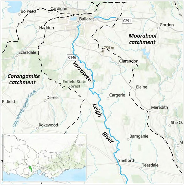
Yarrowee River (rising in Ballarat),
Williamson Creek (rising near Clarendon),
Cargerie Creek (rising at Elaine), and
Wilson Creek (rising in Bamganie).
But it can be thought of as a continuation and re-naming of the Yarrowee River (Yaramlok).
The Leigh River officially starts near Mount Mercer at the confluence of the Yarrowee River and Cargerie Creek at an elevation of 325m and ends at an elevation of 60m merging with the Barwon River just past Inverleigh. It drops around 265m over its 61km length. Over time, the river has carved a valley up to 2km across and 60m below the surrounding plains.
The water that flows through Shelford and into the Barwon, makes its way through Lake Connewarre and eventually into Bass Strait at Barwon Heads.

Leigh River and surrounding waterways are under the management of the Corangamite Catchment Management Authority.

Several Shelford locals have volunteered as citizen scientists with the CCMA's Waterwatch program to monitor river health.
On a regular basis observations are recorded and a range of water sample tests conducted.
The data gathered is entered into the Waterwatch portal for anyone to view. Testing takes place at two sites:
Green Links Program
The Corangamite Catchment Management Authority (CCMA) is undertaking a major program to protect and enhance river banks through weed removal and revegitation. The Green Links program includes a stretch of river along the Shelford Common and will run for three years. The work will be carried out by the CCMA in coordination with the Recreation Reserve committee. Landcare is supporting the revegitation phases and coordinating community planting days.

But the Leigh River does have a sinister side.
Stay safe!
Don't enter flood water!
When nearing major flood level (8m) the recreation reserve, cricket pavilion, primary school and some private properties are threatened with inundation.
Being a relatively short river, the Leigh rises and drops quickly when a rain event occurs within it's catchment.
Flood heights are in metres, but are a pretty arbitrary measure from a nominal point in the riverbed. There are gauge markers on and near the bridge.
Major floods have been recorded in Shelford in 1880, 1899, 1909, 1933, 1952, 1973, 1978 (7.4m), 1995 (7.35m), 2001, 2011 (7.9m), 2016, 2022 (8m).
Check on the live river height data.
Have a read of the 'latest' Shelford Local Flood Guide.